
South Korea Geospatial Analytics Market Size, Share, Trends and Forecast by Type, End Use Industry, and Region, 2026-2034
South Korea Geospatial Analytics Market Size and Share:
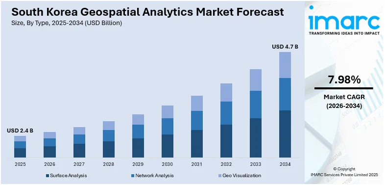
The South Korea geospatial analytics market size was valued at USD 2.4 Billion in 2025. Looking forward, IMARC Group estimates the market to reach USD 4.7 Billion by 2034, exhibiting a CAGR of 7.98% from 2026-2034. The market expansion is being catalyzed through smart city development, AI-mapping, and growing demand for real-time location data. Industry adoption, investments by the government, and adoption of 5G are further boosting market growth.
|
Report Attribute
|
Key Statistics
|
|---|---|
|
Base Year
|
2025 |
|
Forecast Years
|
2026-2034
|
|
Historical Years
|
2020-2025
|
| Market Size in 2025 | USD 2.4 Billion |
| Market Forecast in 2034 | USD 4.7 Billion |
| Market Growth Rate (2026-2034) | 7.98% |
Government initiatives and increasing investments in smart infrastructure are key drivers of South Korea’s geospatial analytics market. For instance, in February 2025, the Republic of Korea announced plans to allocate 414.2 Billion won (USD 285 Million) by 2031 to advance cutting-edge technologies, stimulate progress across sectors, and promote future economic expansion. Geospatial data are the backbone of urban development projects such as smart cities and transport planning, for effective decision-making. The government is proactively incorporating geographic information systems (GIS) into public services, supporting disaster management, environmental monitoring, and infrastructure maintenance. As there has been rapid growth in satellite imagery and remote sensing technologies, geospatial analytics is now becoming crucial to urban planning, real estate management, and land-use optimization.
To get more information on this market Request Sample
Technological advancements and the rise of artificial intelligence (AI) are accelerating geospatial analytics adoption in South Korea. The integration of AI and machine learning enhances predictive analytics, enabling more accurate spatial modeling and real-time mapping. Additionally, the expansion of cutting-edge networks is further improving data collection and processing capabilities, allowing for high-resolution spatial analysis. For instance, in 2024, South Korea’s Ministry of Science and ICT allocated USD 4.7 Million (6.2 billion won) for developing core technologies for 3GPP-based satellite communication terminals to enhance next-generation communication networks. As digital transformation progresses, businesses and government agencies increasingly rely on geospatial intelligence to optimize operations, improve decision-making, and drive sustainable development initiatives.
South Korea Geospatial Analytics Market Trends:
Integration of AI and Machine Learning in Geospatial Analytics
The integration of artificial intelligence (AI) and machine learning is revolutionizing South Korea’s geospatial analytics market. These technologies enhance spatial data processing, automate pattern recognition, and improve predictive modeling. AI-powered geospatial solutions are increasingly used in disaster risk assessment, traffic optimization, and environmental monitoring. Advanced algorithms analyze vast datasets from satellite imagery, drones, and IoT sensors, enabling real-time decision-making. For instance, in October 2024, RGB Labs unveiled Arion, an AI-enabled edge computer for unmanned vehicles, allowing for real-time computing, autonomy, and AI-based integration in drones, robots, and surveillance networks for defense, logistics, disaster relief, and infrastructure monitoring. As AI capabilities evolve, geospatial analytics is becoming more efficient, precise, and scalable, driving innovation across industries such as defense, logistics, and smart city development.
Expansion of 5G-Enabled Geospatial Applications
The expansion of 5G networks in South Korea is accelerating the growth of geospatial analytics by enabling real-time data collection and high-speed processing. For instance, as per industry reports, in 2024, approximately 21% of mobile traffic operates on 5G networks in South Korea, highlighting the country's growing reliance on high-speed connectivity for communication and digital services. Enhanced connectivity supports advanced applications, such as autonomous vehicles, smart grids, and remote monitoring systems that rely on continuous spatial data streams. Urban planners and public agencies leverage 5G-powered geospatial insights for traffic management, disaster response, and infrastructure optimization. The combination of 5G and geospatial analytics is enhancing precision in location-based services, improving situational awareness, and expanding opportunities for businesses in telecommunications, transportation, and environmental monitoring sectors.
Growth of Location-Based Services in Urban Development
Location-based services (LBS) are becoming a significant trend in South Korea’s geospatial analytics market, particularly in urban planning and smart city initiatives. Municipalities are utilizing real-time geospatial data to enhance mobility solutions, improve public safety, and optimize land use. With increased smartphone penetration and IoT adoption, geospatial data is becoming essential for personalized services and operational efficiency. The demand for real-time geospatial insights is driving innovation, supporting seamless navigation, and improving decision-making processes in rapidly evolving urban environments. For instance, in May 2024, Swift Navigation collaborated with SK Telecom to launch AI-powered location-based products in South Korea, upgrading GNSS accuracy with Skylark's cloud-based positioning service, enhancing mobility, UAVs, ADAS vehicles, and tracking systems with centimeter accuracy.
South Korea Geospatial Analytics Industry Segmentation:
IMARC Group provides an analysis of the key trends in each segment of the South Korea geospatial analytics market, along with forecasts at the country and regional levels from 2026-2034. The market has been categorized based on type and end use industry.
Analysis by Type:
- Surface Analysis
- Network Analysis
- Geo Visualization
Surface analysis in South Korea’s geospatial analytics market is widely used for terrain modeling, environmental assessment, and infrastructure development. This method processes elevation data from satellites, LiDAR, and remote sensing technologies to analyze landforms, watershed patterns, and soil composition. Urban planners and environmental agencies utilize surface analysis to assess flood risks, optimize land use, and enhance climate resilience. Advancements in AI and machine learning improve accuracy, enabling precise simulations for construction projects, disaster management, and natural resource planning, supporting sustainable development initiatives across various sectors, contributing to the South Korea geospatial analytics market share.
Network analysis plays a crucial role in optimizing transportation, logistics, and communication systems in South Korea. This geospatial technique examines spatial relationships between interconnected points, improving route planning, traffic flow management, and infrastructure efficiency. Governments and private enterprises leverage network analysis for emergency response planning, utility distribution, and supply chain optimization. With the expansion of smart city initiatives, AI-powered network models enhance predictive capabilities, reducing congestion and improving mobility solutions. As real-time geospatial data integration increases, network analysis is becoming essential for enhancing operational efficiency and urban connectivity.
Geo visualization transforms complex geospatial data into interactive maps, 3D models, and real-time dashboards, enhancing decision-making across industries in South Korea. This segment is widely applied in urban planning, disaster management, and defense, providing dynamic visual representations of spatial data. High-resolution imagery from satellites and drones, combined with AI-driven analytics, enables precise insights into land use, environmental changes, and infrastructure development. Geo visualization tools enhance situational awareness for businesses and government agencies, improving strategic planning and risk assessment. As geospatial technologies advance, demand for intuitive, real-time visualization solutions continues to grow across multiple sectors.
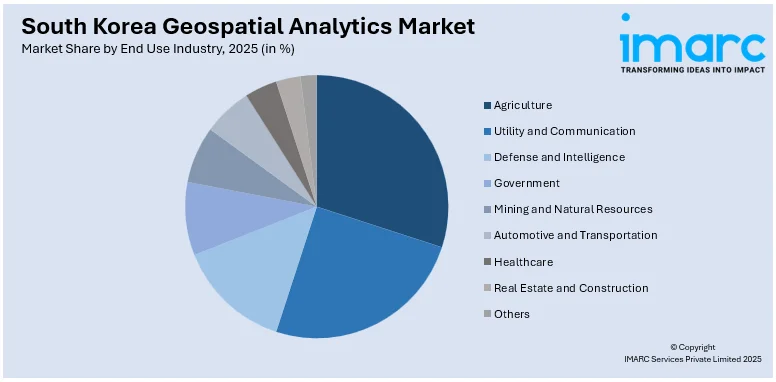
Analysis by End Use Industry:
Access the comprehensive market breakdown Request Sample
- Agriculture
- Utility and Communication
- Defense and Intelligence
- Government
- Mining and Natural Resources
- Automotive and Transportation
- Healthcare
- Real Estate and Construction
- Others
Geospatial analytics is transforming South Korea’s agriculture sector by optimizing crop management, precision farming, and resource allocation. Remote sensing and satellite imagery help monitor soil health, predict yield potential, and assess weather impacts. AI-powered analytics improve irrigation planning and pest control, enhancing productivity while reducing environmental impact. Farmers utilize GIS-based tools for land-use optimization and supply chain efficiency. As agritech adoption increases, geospatial data integration is becoming essential for sustainable farming practices and improving food security in South Korea.
The utility and communication sector in South Korea leverages geospatial analytics for infrastructure planning, asset management, and service optimization. GIS-based systems help utility providers monitor power grids, water distribution networks, and gas pipelines, ensuring efficient operations and reducing downtime. In telecommunications, geospatial data enhances network coverage planning, 5G deployment, and fiber-optic expansion. Predictive analytics improve maintenance schedules and fault detection, minimizing service disruptions. As smart grid technology advances, geospatial solutions are becoming vital for optimizing energy distribution and connectivity.
South Korea’s defense and intelligence sector relies on geospatial analytics for surveillance, strategic planning, and threat assessment. High-resolution satellite imagery, drone reconnaissance, and AI-driven mapping enhance military situational awareness. Defense agencies use geospatial intelligence for border security, mission planning, and real-time monitoring of critical infrastructure. Advanced analytics support risk assessment and emergency response coordination. As geopolitical challenges evolve, continuous investment in geospatial technologies strengthens national security and enhances precision in defense operations, intelligence gathering, and disaster response management.
Government agencies in South Korea utilize geospatial analytics for urban planning, environmental management, and disaster response. GIS-based tools assist in land administration, public infrastructure development, and traffic optimization. Real-time spatial data improves emergency response planning, aiding in flood control and wildfire prevention. Smart city initiatives integrate geospatial solutions to enhance mobility, sustainability, and resource allocation. As digital transformation accelerates, the government is increasingly relying on geospatial intelligence to improve decision-making, optimize public services, and drive efficient governance.
Geospatial analytics plays a crucial role in South Korea’s mining and natural resources sector, improving exploration efficiency and environmental monitoring. Remote sensing technology enables precise mapping of mineral deposits, reducing exploration costs and risks. GIS-based analysis helps optimize extraction sites, manage land reclamation, and monitor ecological impacts. Real-time geospatial data enhances resource planning and regulatory compliance, ensuring sustainable operations. As the demand for critical minerals increases, the South Korea geospatial analytics market outlook is becoming essential for responsible resource management and operational efficiency.
The automotive and transportation industry in South Korea integrates geospatial analytics for traffic management, route optimization, and autonomous vehicle development. AI-powered mapping enhances logistics efficiency, improving fleet operations and reducing congestion. Real-time spatial data supports smart mobility solutions, including electric vehicle charging infrastructure and intelligent transportation systems. Automakers leverage geospatial insights for supply chain optimization and location-based services. As urban mobility solutions evolve, geospatial analytics is driving advancements in connected vehicles, ride-sharing applications, and transportation infrastructure planning.
Geospatial analytics enhances South Korea’s healthcare sector by optimizing resource allocation, disease tracking, and emergency response. GIS-based mapping helps hospitals and health agencies analyze patient demographics, improve accessibility, and plan healthcare infrastructure. Epidemiological studies use geospatial data to track disease outbreaks and predict healthcare demands. Ambulance routing and disaster response planning benefit from real-time spatial insights, ensuring efficient emergency services. As health systems modernize, geospatial intelligence is becoming crucial for data-driven decision-making and enhancing public health strategies.
The real estate and construction industry in South Korea relies on geospatial analytics for site selection, land valuation, and urban development. High-resolution mapping improves risk assessment, zoning regulations, and infrastructure planning. Developers use GIS-based tools for project feasibility analysis, optimizing land use and environmental impact assessments. Smart city initiatives integrate geospatial solutions to enhance sustainable construction practices. As urbanization accelerates, geospatial intelligence supports efficient land management, reduces project risks, and enhances decision-making in commercial and residential property development.
Regional Analysis:
- Seoul Capital Area
- Yeongnam (Southeastern Region)
- Honam (Southwestern Region)
- Hoseo (Central Region)
- Others
According to the South Korea geospatial analytics market forecast, the Seoul Capital Area, encompassing Seoul, Incheon, and Gyeonggi Province, represents the prominent market for geospatial analytics in South Korea. Smart city initiatives, urban planning projects, and advanced transportation systems drive demand for GIS-based solutions. High population density and rapid infrastructure development require precise geospatial data for traffic management, public safety, and environmental monitoring. Government agencies and technology firms leverage AI-powered spatial analysis to optimize land use, energy distribution, and disaster response, making the region a leader in geospatial innovation.
Yeongnam, home to major industrial cities like Busan, Daegu, and Ulsan, relies on geospatial analytics for logistics, manufacturing, and port management. South Korea’s largest ports use real-time geospatial data for maritime navigation, cargo handling, and security. The automotive and heavy industries integrate GIS solutions for supply chain optimization and factory site planning. Urban expansion in Busan and Daegu necessitates geospatial intelligence for sustainable development. As smart infrastructure projects advance, demand for high-precision mapping and AI-driven spatial analysis continues to grow.
Honam, covering Jeolla provinces, is experiencing increased geospatial analytics adoption for agriculture, environmental conservation, and tourism development. Precision farming techniques rely on satellite imagery and remote sensing for crop monitoring and irrigation management. Coastal cities like Gwangju and Mokpo integrate GIS solutions for flood control, land planning, and disaster preparedness. The tourism sector utilizes location-based analytics to enhance visitor experiences and infrastructure planning. As Honam expands renewable energy projects, geospatial technologies play a crucial role in wind farm placement and ecological impact assessments.
Hoseo, which includes Chungcheong provinces and the city of Daejeon, is a growing hub for geospatial research and technology-driven urban development. Home to leading research institutions, the region fosters innovation in GIS applications for smart cities, transportation, and defense. Daejeon’s role as a science and technology center drives demand for AI-powered geospatial analytics in precision mapping and infrastructure planning. The agricultural sector benefits from GIS-based land management, while regional governments utilize spatial data for resource allocation and sustainable growth. Hoseo’s strategic location supports continued investment in geospatial intelligence and digital transformation initiatives.
Competitive Landscape:
South Korea’s geospatial analytics market is highly competitive, with technology firms, government agencies, and startups driving innovation. Leading players invest in AI-driven analytics, 5G-enabled applications, and real-time spatial data solutions to enhance decision-making. Government-backed smart city projects and defense applications fuel competition among domestic and international providers. Cloud-based geospatial platforms and IoT integration are reshaping service offerings, while partnerships between tech firms and public institutions strengthen market presence. For instance, in June 2023, South Korean satellite company TelePIX signed a deal with Poland's SatRev to provide satellite imagery, South Korea's first export of observation data. Demand for location intelligence in urban planning, logistics, and disaster management continues to grow, pushing companies to refine data accuracy, scalability, and predictive capabilities to maintain a competitive
The report provides a comprehensive analysis of the competitive landscape in the South Korea geospatial analytics market with detailed profiles of all major companies.
Latest News and Developments:
- In February 2025, HFR Mobile launched South Korea's first-ever Private 5G public safety network in Gimcheon City as part of a government-supported initiative. This AI-based platform improves surveillance, danger detection, and urban security, pushing the development of smart city infrastructure and municipal digitalization across the country.
- In April 2024, Indonesia's TechnoGIS collaborated with Korea's GI E&S to implement geospatial solutions based on satellite imagery solutions for geomaritime and geoclimate problems, supporting informed decision-making as well as innovating maritime and climate industries in Indonesia.
- In July 2024, Bayanat partnered with South Korea's Autonomous a2z to create autonomous systems in the UAE and MENA region, utilizing AI-driven geospatial solutions to improve smart mobility, transport infrastructure, and autonomous vehicle deployment.
- In October 2024, Samsung Electronics and KT Corporation announced they will deploy South Korea’s first Private 5G network for the ROK Navy’s Smart Naval Port project, enhancing base security, operations, and digital twin-based management with AI-powered surveillance and intelligent battleship operation systems.
South Korea Geospatial Analytics Market Report Scope:
| Report Features | Details |
|---|---|
| Base Year of the Analysis | 2025 |
| Historical Period | 2020-2025 |
| Forecast Period | 2026-2034 |
| Units | Billion USD |
| Scope of the Report |
Exploration of Historical Trends and Market Outlook, Industry Catalysts and Challenges, Segment-Wise Historical and Future Market Assessment:
|
| Types Covered | Surface Analysis, Network Analysis, Geo Visualization |
| End Use Industries Covered | Agriculture, Utility and Communication, Defense and Intelligence, Government, Mining and Natural Resources, Automotive and Transportation, Healthcare, Real Estate and Construction, Others |
| Regions Covered | Seoul Capital Area, Yeongnam (Southeastern Region), Honam (Southwestern Region), Hoseo (Central Region), Others |
| Customization Scope | 10% Free Customization |
| Post-Sale Analyst Support | 10-12 Weeks |
| Delivery Format | PDF and Excel through Email (We can also provide the editable version of the report in PPT/Word format on special request) |
Key Benefits for Stakeholders:
- IMARC’s report offers a comprehensive quantitative analysis of various market segments, historical and current market trends, market forecasts, and dynamics of the South Korea geospatial analytics market from 2020-2034.
- The research study provides the latest information on the market drivers, challenges, and opportunities in the South Korea geospatial analytics market.
- Porter's Five Forces analysis assists stakeholders in assessing the impact of new entrants, competitive rivalry, supplier power, buyer power, and the threat of substitution. It helps stakeholders to analyze the level of competition within the South Korea geospatial analytics industry and its attractiveness.
- Competitive landscape allows stakeholders to understand their competitive environment and provides an insight into the current positions of key players in the market.
Key Questions Answered in This Report
The South Korea geospatial analytics market was valued at USD 2.4 Billion in 2025.
The market is driven by advancements in artificial intelligence, increasing 5G adoption, and growing demand for smart city solutions. Additionally, government initiatives in urban planning, disaster management, and defense strengthen market growth.
IMARC estimates the global South Korea geospatial analytics market to reach USD 4.7 Billion in 2034, exhibiting a CAGR of 7.98% during 2026-2034?
Need more help?
- Speak to our experienced analysts for insights on the current market scenarios.
- Include additional segments and countries to customize the report as per your requirement.
- Gain an unparalleled competitive advantage in your domain by understanding how to utilize the report and positively impacting your operations and revenue.
- For further assistance, please connect with our analysts.
 Request Customization
 Speak to an Analyst
 Request Brochure
 Inquire Before Buying
Benefits of Customization
- Personalize this research
- Triangulate with your data
- Get data as per your format and definition
- Gain a deeper dive into a specific application, geography, customer, or competitor
- Any level of personalization
Get in Touch With Us
UNITED STATES
Phone: +1-201-971-6302
INDIA
Phone: +91-120-433-0800
UNITED KINGDOM
Phone: +44-753-714-6104
Email: sales@imarcgroup.com
Client Testimonials


.webp)


