
Satellite-based Earth Observation Market Report by Solution (Data, Value Added Services), End User (Defense and Intelligence, Infrastructure and Engineering, Agriculture, Energy and Power, and Others), and Region 2026-2034
Global Satellite-based Earth Observation Market:
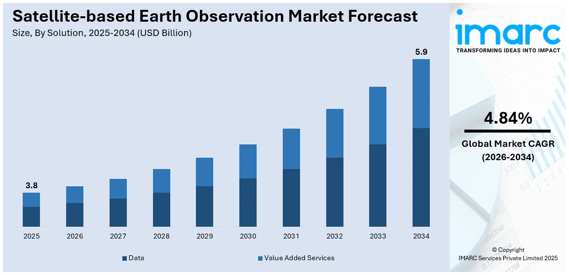
The global satellite-based earth observation market size reached USD 3.8 Billion in 2025. Looking forward, IMARC Group expects the market to reach USD 5.9 Billion by 2034, exhibiting a growth rate (CAGR) of 4.84% during 2026-2034. The increasing demand for accurate weather forecasting and environmental monitoring is stimulating the market.
|
Report Attribute
|
Key Statistics
|
|---|---|
|
Base Year
|
2025
|
|
Forecast Years
|
2026-2034
|
|
Historical Years
|
2020-2025
|
|
Market Size in 2025
|
USD 3.8 Billion |
|
Market Forecast in 2034
|
USD 5.9 Billion |
| Market Growth Rate 2026-2034 | 4.84% |
Satellite-based Earth Observation Market Analysis:
- Major Market Drivers: The rising investments by governments in space programs to improve disaster management and national security are propelling the market.
- Key Market Trends: The advancements in satellite technology are making data collection more affordable and accessible, which is acting as a significant growth-inducing factor.
- Competitive Landscape: Some of the major market companies include Airbus SE, BAE Systems plc, GeoOptics Inc., ImageSat International N.V., L3Harris Technologies Inc., Lockheed Martin Corporation, Maxar Technologies Inc., Northrop Grumman Corporation, OHB System AG (OHB SE), Planet Labs PBC, Raytheon Technologies Corporation, and Thales Group, among many others.
- Geographical Trends: North America exhibits a clear dominance in the market, driven by strong private sector involvement and advanced infrastructure, coupled with innovative applications in agriculture, urban planning, and disaster management.
- Challenges and Opportunities: The high cost of satellite deployment is hindering the market. However, increasing collaborations between private companies and governments to share resources and reduce expenses will continue to strengthen the market over the forecast period.
To get more information on this market Request Sample
Satellite-based Earth Observation Market Trends:
Advancements in High-Resolution Imaging Technology
The development of higher-resolution imaging technology in satellites enhances the clarity and precision of earth observation data. In contrast, this allows for detailed monitoring of environmental changes, infrastructure, and terrain features, thereby improving applications across industries, such as agriculture, urban planning, and military operations. For instance, in October 2024, ICEYE unveiled Dwell Precise, a new SAR imaging mode offering 25 cm resolution. This is based on 1200 MHz radar bandwidth, which enhances object identification and data quality, supporting applications like defense and infrastructure monitoring while advancing satellite-based earth observation market growth.
Growing Demand for Real-Time Data Processing
The ability to process satellite data in real time is becoming increasingly important for industries requiring immediate insights. Moreover, this allows faster decision-making in areas, including environmental monitoring, maritime navigation, and emergency response, thereby enabling timely interventions and actions based on up-to-date information. For instance, in August 2024, ESA launched the Φsat-2 satellite equipped with AI, which processes data in real time. Also, enhancing applications like cloud detection, maritime monitoring, and street map generation, revolutionizing environmental monitoring and disaster response efforts.
Increasing Applications in Disaster Management
Satellite-based earth observation plays an important role in disaster management by providing accurate data for monitoring natural disasters like floods, wildfires, and hurricanes. Furthermore, it aids in early warning systems, resource allocation, and post-disaster recovery efforts, thereby improving the overall efficiency of disaster preparedness and response. For instance, in August 2024, ISRO launched the EOS-08 earth observation satellite, advancing satellite-based surveillance, disaster, and environmental monitoring, which is equipped with electro optical infrared and GNSS-R payloads. Also, the 175.5 kg satellite enhances applications like soil moisture assessment, flood detection, and industrial disaster monitoring.
Global Satellite-based Earth Observation Industry Segmentation:
IMARC Group provides an analysis of the key trends in each segment of the market, along with the market forecast at the global, regional, and country levels for 2026-2034. Our report has categorized the market based on solution and end user.
Breakup by Solution:
- Data
- Value Added Services
Data currently dominates the market
The report has provided a detailed breakup and analysis of the market based on the solution. This includes data and value added services. According to the report, data represented the largest market segmentation.
Data exhibits a clear dominance in the market with solutions like the Copernicus program's Sentinel satellites providing detailed environmental monitoring. Furthermore, these satellites deliver valuable data for climate change, agriculture, and disaster management, thereby elevating satellite-based earth observation market share.
Breakup by End User:
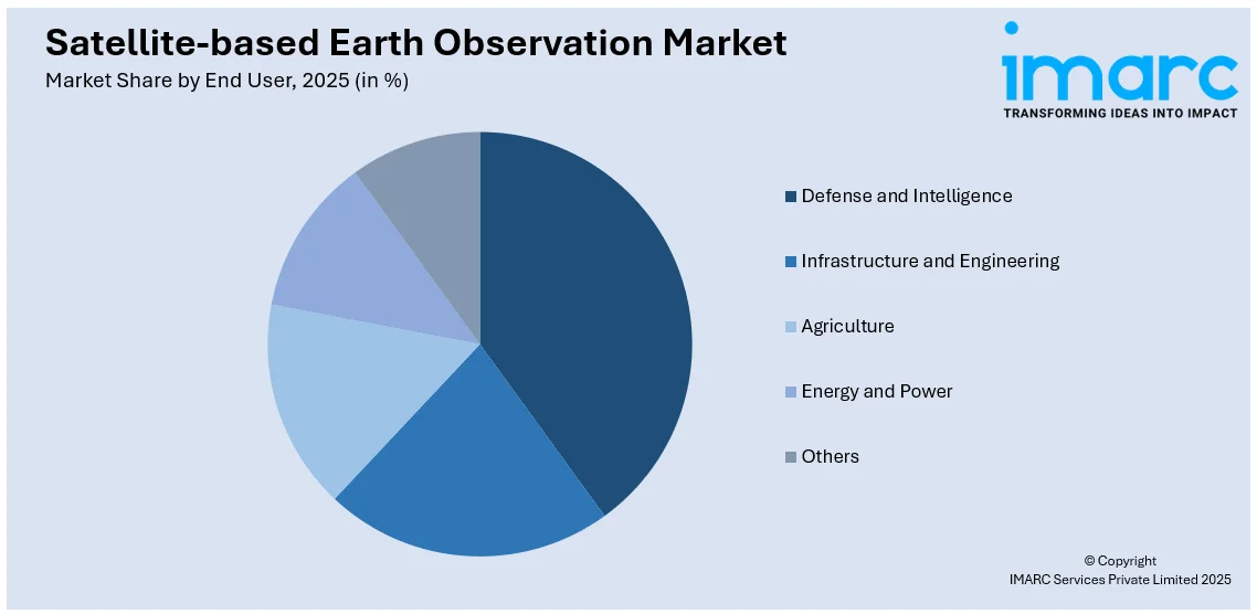
Access the comprehensive market breakdown Request Sample
- Defense and Intelligence
- Infrastructure and Engineering
- Agriculture
- Energy and Power
- Others
Defense and intelligence currently hold the largest satellite-based earth observation market share
The report has provided a detailed breakup and analysis of the market based on the end user. This includes defense and intelligence, infrastructure and engineering, agriculture, energy and power, and others. According to the report, defense and intelligence represented the largest market segmentation.
Defense and intelligence lead the market due to their need for high-resolution imagery for surveillance and reconnaissance. For example, the WorldView-4 satellite, launched by DigitalGlobe, provided detailed images for military applications.
Breakup by Region:
- North America
- United States
- Canada
- Asia-Pacific
- China
- Japan
- India
- South Korea
- Australia
- Indonesia
- Others
- Europe
- Germany
- France
- United Kingdom
- Italy
- Spain
- Russia
- Others
- Latin America
- Brazil
- Mexico
- Others
- Middle East and Africa
North America currently dominates the market
The market outlook report has also provided a comprehensive analysis of all the major regional markets, which include North America (the United States and Canada); Asia Pacific (China, Japan, India, South Korea, Australia, Indonesia, and others); Europe (Germany, France, the United Kingdom, Italy, Spain, Russia, and others); Latin America (Brazil, Mexico, and others); and the Middle East and Africa. According to the report, North America accounted for the largest market share.
North America dominates the market, which is driven by advancements in technology, strong government support, and a robust private sector. In contrast, the region benefits from significant investments in space programs, with NASA and private companies like SpaceX leading major satellite launches. For instance, the Landsat 9 satellite was launched by NASA, enhancing data collection for environmental monitoring. Furthermore, the presence of key industry players and the growing use of satellite data for agriculture, defense, and disaster management further solidify the satellite-based earth observation market share.
Competitive Landscape:
The market research report has provided a comprehensive analysis of the competitive landscape. Detailed profiles of all market companies have also been provided. Some of the key players in the market include:
- Airbus SE
- BAE Systems plc
- GeoOptics Inc.
- ImageSat International N.V.
- L3Harris Technologies Inc.
- Lockheed Martin Corporation
- Maxar Technologies Inc.
- Northrop Grumman Corporation
- OHB System AG (OHB SE)
- Planet Labs PBC
- Raytheon Technologies Corporation
- Thales Group
(Please note that this is only a partial list of the key players, and the complete list is provided in the report.)
Satellite-based Earth Observation Market Recent Developments:
- October 2024: NASA unveiled the ‘Hyperwall’ at the Smithsonian’s National Museum of Natural History, showcasing satellite-based earth observation technology. This immersive exhibit highlights climate change using satellite data and historical records, emphasizing the growing role of satellites in environmental monitoring and research.
- August 2024: ISRO launched the EOS-08 earth observation satellite, advancing satellite-based surveillance, disaster, and environmental monitoring, which is equipped with electro optical infrared and GNSS-R payloads. The 175.5 kg satellite enhances applications like soil moisture assessment, flood detection, and industrial disaster monitoring.
- July 2024: Japan introduced the ALOS-4 earth observation satellite with its new H3 rocket, enhancing disaster response, mapmaking, and military monitoring capabilities.
Satellite-based Earth Observation Market Report Scope:
| Report Features | Details |
|---|---|
| Base Year of the Analysis | 2025 |
| Historical Period | 2020-2025 |
| Forecast Period | 2026-2034 |
| Units | Billion USD |
| Scope of the Report | Exploration of Historical Trends and Market Outlook, Industry Catalysts and Challenges, Segment-Wise Historical and Future Market Assessment:
|
| Solutions Covered | Data, Value Added Services |
| End Users Covered | Defense and Intelligence, Infrastructure and Engineering, Agriculture, Energy and Power, Others |
| Regions Covered | Asia Pacific, Europe, North America, Latin America, Middle East and Africa |
| Countries Covered | United States, Canada, Germany, France, United Kingdom, Italy, Spain, Russia, China, Japan, India, South Korea, Australia, Indonesia, Brazil, Mexico |
| Companies Covered | Airbus SE, BAE Systems plc, GeoOptics Inc., ImageSat International N.V., L3Harris Technologies Inc., Lockheed Martin Corporation, Maxar Technologies Inc., Northrop Grumman Corporation, OHB System AG (OHB SE), Planet Labs PBC, Raytheon Technologies Corporation, Thales Group |
| Customization Scope | 10% Free Customization |
| Post-Sale Analyst Support | 10-12 Weeks |
| Delivery Format | PDF and Excel through Email (We can also provide the editable version of the report in PPT/Word format on special request) |
Key Benefits for Stakeholders:
- IMARC's industry report offers a comprehensive quantitative analysis of various market segments, historical and current market trends, market forecasts, and dynamics of the satellite-based earth observation market from 2020-2034.
- The research report provides the latest information on the market drivers, challenges, and opportunities in the global satellite-based earth observation market.
- The study maps the leading, as well as the fastest-growing, regional markets. It further enables stakeholders to identify the key country-level markets within each region.
- Porter's five forces analysis assists stakeholders in assessing the impact of new entrants, competitive rivalry, supplier power, buyer power, and the threat of substitution. It helps stakeholders to analyze the level of competition within the satellite-based earth observation industry and its attractiveness.
- The competitive landscape allows stakeholders to understand their competitive environment and provides insight into the current positions of key players in the market.
Key Questions Answered in This Report
The satellite-based earth observation market size was valued at USD 3.8 Billion in 2025.
We expect the global satellite-based earth observation market to exhibit a CAGR of 4.84% during 2026-2034.
The emerging trend of automated self-driving vehicles, along with the growing demand for satellite-based earth observation systems for effective car navigation systems, is primarily driving the global satellite-based earth observation market.
The sudden outbreak of the COVID-19 pandemic had led to the implementation of stringent lockdown regulations across several nations, resulting in the temporary closure of numerous end-use industries for satellite-based earth observation systems.
Based on the solution, the global satellite-based earth observation market has been segregated into data and value-added services, where data currently holds the largest market share.
Based on the end user, the global satellite-based earth observation market can be bifurcated into defense and intelligence, infrastructure and engineering, agriculture, energy and power, and others. Currently, defense and intelligence exhibit a clear dominance in the market.
On a regional level, the market has been classified into North America, Asia-Pacific, Europe, Latin America, and Middle East and Africa, where North America currently dominates the global market.
Some of the major players in the global satellite-based earth observation market include Airbus SE, BAE Systems plc, GeoOptics Inc., ImageSat International N.V., L3Harris Technologies Inc., Lockheed Martin Corporation, Maxar Technologies Inc., Northrop Grumman Corporation, OHB System AG (OHB SE), Planet Labs PBC, Raytheon Technologies Corporation, and Thales Group.
Need more help?
- Speak to our experienced analysts for insights on the current market scenarios.
- Include additional segments and countries to customize the report as per your requirement.
- Gain an unparalleled competitive advantage in your domain by understanding how to utilize the report and positively impacting your operations and revenue.
- For further assistance, please connect with our analysts.
 Request Customization
 Speak to an Analyst
 Request Brochure
 Inquire Before Buying




.webp)




.webp)

