
3D Mapping and Modeling Market Size, Share, Trends and Forecast by Component, Application, End-Use Industry, and Region, 2026-2034
3D Mapping and Modeling Market Size and Share:
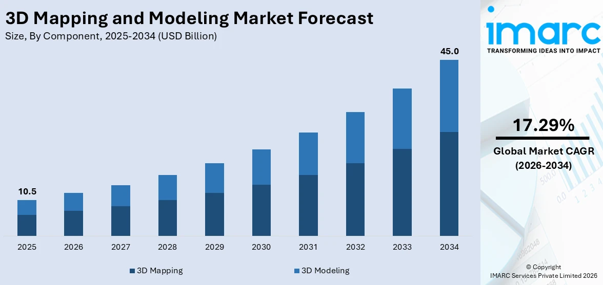
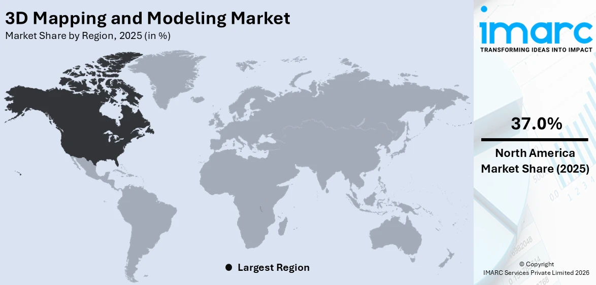
The global 3D mapping and modeling market size was valued at USD 10.5 Billion in 2025. Looking forward, IMARC Group estimates the market to reach USD 45.0 Billion by 2034, exhibiting a CAGR of 17.29% during 2026-2034. North America currently dominates the market, holding a significant market share of over 37.0% in 2025. The market is experiencing steady growth driven by the growing application in the media and entertainment industry, accelerating demand for geographic information system (GIS) applications, the widespread adoption in the construction sector, and the introduction of 3D-enabled devices.
|
Report Attribute
|
Key Statistics
|
|---|---|
|
Base Year
|
2025
|
|
Forecast Years
|
2026-2034
|
|
Historical Years
|
2020-2025
|
|
Market Size in 2025
|
USD 10.5 Billion |
|
Market Forecast in 2034
|
USD 45.0 Billion |
| Market Growth Rate (2026-2034) | 17.29% |
The 3D mapping and modeling market growth is driven by technological advancements in AI, LiDAR, and cloud computing, enabling high-precision mapping and real-time visualization. The emergence of smart cities, along with digital twins, creates an increased market demand for urban planning, construction, and infrastructure projects. The gaming sector and entertainment industry use 3D modeling to generate immersive experiences whereas autonomous vehicles and drones need precise 3D maps for their navigation systems. The defense sector along with healthcare institutions and geospatial analytics operations propel the market growth forward. Additionally, cloud-based solutions enhance accessibility and scalability, promoting wider adoption. The push for automation, improved data accuracy, and cost-effective solutions also drives market expansion. The factors, collectively, are creating a 3D mapping and modeling market outlook across the globe.
To get more information on this market Request Sample
The 3D mapping and modeling market in the United States is driven by rapid advancements in AI, LiDAR, and cloud computing, enhancing precision and efficiency. Government initiatives for smart cities and infrastructure development fuel demand, especially in urban planning, transportation, and construction. The use of 3D modeling within gaming, real estate and film industries enables users to experience virtual walkthroughs while creating immersive environments. High-resolution 3D map requirements for autonomous vehicles and drone navigation enhance market growth at present. The market experiences enhanced scalability because of the rising popularity of digital twins, geospatial analytics, and cloud-based solutions. The competitive environment develops through strategic team-ups between technology organizations and startups as well as federal agencies. For instance, in January 2025, leading international urban planning platform provider Simplex 3D announced its arrival in the US market along with its partnership with First American Title Insurance Company, the key subsidiary of First American Financial Corporation. With the help of Simplex 3D's technology, developers, architects, urban planners, real estate agents, and other B2B and B2G clients and partners can run an easy-to-use 3D private workspace with cutting-edge features.
3D Mapping and Modeling Market Trends:
Technological advancements in sensing and imaging technologies
The continuous evolution and enhancement of sensing and imaging technologies are pivotal factors driving the growth of the market. Advanced LiDAR (Light Detection and Ranging) systems, high-resolution cameras, and other sensor technologies enable more accurate and detailed data capture. These technological improvements contribute to the creation of highly realistic and precise 3D models, meeting the increasing demand for detailed spatial information in various industries. As these technologies become more affordable and accessible, businesses across sectors such as urban planning, construction, and infrastructure development are increasingly adopting 3D mapping and modeling solutions to improve decision-making processes and operational efficiency.
Rising demand for geographic information system (GIS) applications
The growing demand for Geographic Information System (GIS) applications represents one of the key 3D mapping and modeling market trends. According to the IMARC Group, the India geographic information system (GIS) market reached USD 547.3 Million in 2023. GIS plays a crucial role in diverse industries, including urban planning, agriculture, disaster management, and environmental monitoring. Integrating 3D mapping and modeling into GIS applications enhances the visual representation of geospatial data, providing a more immersive and comprehensive understanding of the terrain. This increased spatial awareness enables better-informed decision-making, fostering the adoption of 3D mapping technologies. As organizations recognize the value of 3D GIS in optimizing resource allocation and improving planning processes, the market experiences substantial growth.
Growing applications in augmented reality (AR) and virtual reality (VR)
The expansion of Augmented Reality (AR) and Virtual Reality (VR) applications across industries is a key factor propelling the market forward. These technologies leverage 3D models to create immersive and interactive experiences, ranging from virtual tours in real estate to training simulations in healthcare and manufacturing. According to reports, significant improvements in surgical skills were observed after AR-based training sessions. Research showed a 20% increase in precision, 33% more timesaving, 60% fewer mistakes, and a 21% increase in procedural success rates. As AR and VR applications become integral parts of various sectors, the demand for high-quality and realistic 3D content continues to rise. The market, therefore, experiences a rise in growth as businesses seek to leverage these technologies for training, marketing, and customer engagement. The synergy between 3D mapping and AR/VR not only enhances user experiences but also opens up new opportunities for innovation and differentiation in the competitive landscape, thereby 3D mapping and modelling market demand.
3D Mapping and Modeling Industry Segmentation:
IMARC Group provides an analysis of the key trends in each segment of the global 3D mapping and modeling market, along with forecasts at the global, regional, and country levels from 2026-2034. The market has been categorized based on component, application, and end-use industry.
Analysis by Component:
- 3D Mapping
- 3D Modeling
3D mapping stand as the largest component in 2025, holding around 65.3% of the market. The 3D mapping market segment provides tools and software solutions that generate exact three-dimensional representations for physical spaces alongside objects or terrains. The accurate representation of physical spaces occurs through this essential component when used in cartography and urban planning as well as geospatial analysis. 3D mapping requires spatial data acquisition and processing to produce realistic virtual models. The sector extensively applies this technology in construction projects because it enables detailed assessment of land features for planning and design purposes. The 3D mapping segment showcases growing success because of new LiDAR technology along with improved satellite imaging enables industries to generate top-notch detailed real-world models.
Analysis by Application:
Access the comprehensive market breakdown Request Sample
- Projection Mapping
- Texture Mapping
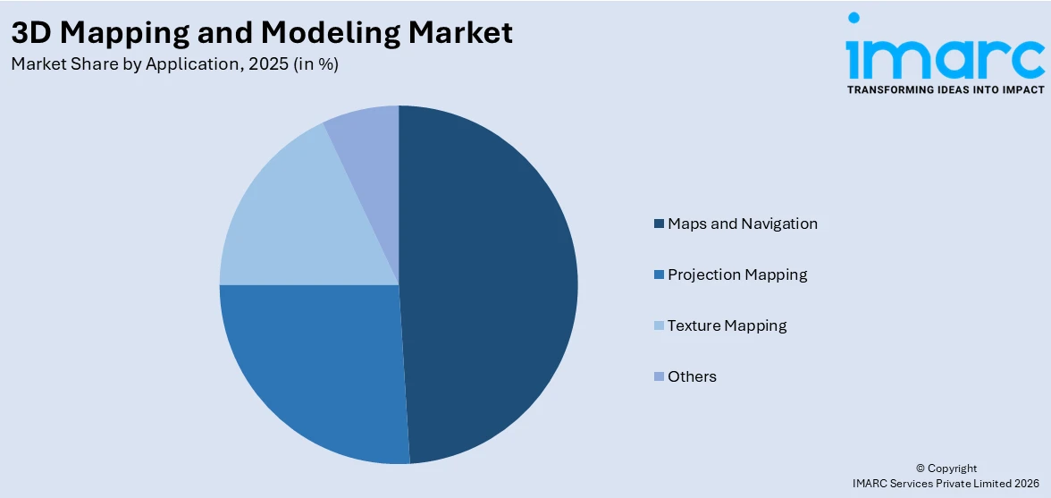
- Maps and Navigation
- Others
Maps and navigation leads the market with around 48.9% of the 3D mapping and modeling market share in 2025. Maps and navigation play a fundamental role in providing spatial information for a wide range of applications. The precise nature of modern business operations requires accurate and current maps for transportation sector planning and logistics operations as well as location-based service management processes. The combination of GPS technology with rising map involvement in mobile devices has led to major growth in the maps and navigation segment. The market enables businesses to maximize their supply chain operations while delivering improved navigation applications to users and optimizing operational processes. As smart cities and IoT ecosystems continue to evolve, the demand for precise and real-time maps and navigation solutions is expected to drive sustained growth in this pivotal market segment.
Analysis by End-Use Industry:
- Construction Industry
- Transportation Industry
- Automobile Industry
- Entertainment Industry
- Healthcare Industry
- Others
Construction industry leads the market with around 27.1% of the market share in 2025. The construction industry stands as a significant segment in the market, utilizing these technologies for project planning, design, and visualization. Through 3D mapping capabilities, construction experts can examine site conditions while topographers assess land features during facility planning, and architects use 3D modeling to create detailed designs followed by virtual model assessments for stakeholders. The construction sector adopts 3D mapping and modeling technologies more frequently to achieve improved efficiency and accuracy, which drives an ongoing growth of this adoption method for architects, engineers, and project managers to collaborate more efficiently.
Regional Analysis:
To get more information on the regional analysis of this market Request Sample
- North America
- United States
- Canada
- Asia Pacific
- China
- Japan
- India
- South Korea
- Australia
- Indonesia
- Others
- Europe
- Germany
- France
- United Kingdom
- Italy
- Spain
- Russia
- Others
- Latin America
- Brazil
- Mexico
- Others
- Middle East and Africa
In 2025, North America accounted for the largest market share of over 37.0%. The market dominance in North America occurs due to its advanced technological infrastructure along with the early adoption of spatial technology advances and an increasing number of tech-based industries. These high-profile sectors demonstrate the geographical importance of North America in the market. The market leads from North America, where major enterprises have headquarters in the region along with high levels of understanding and use of 3D mapping solutions. Research and development (R&D) investments coupled with continuous innovation have made North America a dominating force in global market leadership.
Key Regional Takeaways:
United States 3D Mapping and Modeling Market Analysis
In 2025, the United States accounted for the largest 3D mapping and modelling market share of over 85.90% in North America. The 3D mapping and modeling market in the United States is experiencing substantial growth driven by a range of factors. Firstly, the demand for advanced technologies in industries, such as construction, automotive, aerospace, and urban planning, is significantly increasing. The adoption of geographic information systems (GIS) and light detection and ranging (LiDAR) technologies for creating detailed and accurate models is enhancing the capabilities of businesses and government agencies. In line with this, the rising adoption of autonomous vehicles, which rely on precise 3D mapping for navigation, is catalyzing the need for advanced mapping technologies. According to industry reports, sales of autonomous light vehicles in the US is forecasted to reach about 230,000 autonomous mobility-as-a-service units by 2034. Besides this, federal initiatives and investments in infrastructure projects are also contributing to the growth, as accurate mapping is crucial for planning and development. In the United States, for example, large-scale infrastructure programs like the Bipartisan Infrastructure Law aim to modernize roads, bridges, transit systems, and broadband networks. These projects demand precise geospatial data to ensure that they are built with safety, sustainability, and efficiency in mind. Accurate 3D mapping is essential in this context because it helps to create digital models of terrains, existing infrastructure, and construction sites.
Asia Pacific 3D Mapping and Modeling Market Analysis
In the Asia Pacific region, the 3D mapping and modeling market is driven by rapid urbanization, infrastructural development, and technological advancements. Countries like China, India, and Japan are investing heavily in smart city projects and infrastructure upgrades, which demand precise 3D mapping for better planning and resource management. According to CRISIL’s Infrastructure yearbook 2023, India is expected to spend nearly USD 1,727.05 Billion on infrastructure in seven fiscals through 2030. Apart from this, the increasing use of drones and unmanned aerial vehicles (UAVs) in sectors like construction, agriculture, and environmental monitoring is a significant factor in the market’s growth. In the construction sector, drones are widely used for site surveying, project monitoring, and progress tracking. UAVs equipped with LiDAR sensors or high-definition cameras can create precise 3D models of construction sites in a fraction of the time it would take with traditional ground-based methods. This allows for real time data collection and quick decision-making, reducing delays and improving overall project efficiency. In agriculture, drones equipped with specialized sensors are being used to monitor crop health, soil conditions, and overall field performance. Furthermore, governing agencies in the region are also promoting the use of geospatial data and 3D modeling technologies for environmental monitoring, disaster management, and urban planning. The proliferation of industries like gaming, entertainment, and virtual reality is further driving the market, as high-quality 3D models are essential for creating immersive experiences.
Europe 3D Mapping and Modeling Market Analysis
The European automotive sector plays a pivotal role in driving the growth of the 3D mapping and modeling market in the region. With the growing emphasis on autonomous vehicles and advanced driver-assistance systems (ADAS), automotive manufacturers require precise and real-time 3D maps to enhance navigation, improve safety, and optimize performance. As per the European Parliament, the self-driving vehicle industry is predicted to grow rapidly by 2025, developing new jobs and generating earnings of up to USD 662.4 Billion for the EU automotive industry. Europe is home to leading automotive companies investing heavily in the development of autonomous driving technologies, which rely on high-definition 3D mapping to ensure vehicle safety and efficiency. In line with this, the EU's push toward sustainable and smart transportation solutions is further accelerating the adoption of advanced mapping technologies for traffic management, route optimization, and urban mobility. Apart from this, the integration of advanced geospatial technologies into transportation infrastructure, such as smart roads and smart cities, is creating new opportunities for 3D mapping and modeling in Europe. The region's strong regulatory framework surrounding autonomous driving is also driving the demand for accurate, reliable mapping solutions to meet safety standards. Furthermore, there is a rise in the demand for drones in environmental monitoring for capturing geospatial data for mapping forests, wildlife habitats, and water bodies. The ability to create 3D models of terrain and ecosystems enables more accurate assessments and the development of effective management strategies.
Latin America 3D Mapping and Modeling Market Analysis
The Latin American 3D mapping and modeling market is witnessing growth owing to high government investments in infrastructure and urban planning. Many countries in the region are embarking on large-scale projects for transportation, urban development, and environmental monitoring, requiring accurate mapping and modeling solutions. The growing interest in smart city initiatives is also a key factor, as municipalities seek to improve resource management, sustainability, and public services. According to the Institute of the Americas, Latin America accounts for almost 10% of global smart city spending but is experiencing increasing engagement in smart city projects. Additionally, the rise in drone usage for aerial surveys and mapping is opening new opportunities in industries like agriculture, construction, and mining.
Middle East and Africa 3D Mapping and Modeling Market Analysis
In the Middle East and Africa, the 3D mapping and modeling market is driven by rapid infrastructure development, particularly in countries like the UAE and Saudi Arabia. These nations are investing heavily in smart city projects, such as the development of NEOM and other futuristic urban developments, which rely on 3D mapping technologies for planning and execution. Additionally, the increasing demand for high-definition mapping in the defense, oil and gas, and construction sectors, is contributing to 3D mapping and modeling market growth. The thriving construction sector in the region is bolstering the market growth. The construction industry across the Middle East and North Africa (MENA) region has demonstrated extraordinary resilience, awarding USD 101 billion in projects during the first half of the year. Furthermore, geospatial data is increasingly being used for environmental monitoring and disaster management, which further supports the adoption of advanced 3D mapping solutions in the region.
Competitive Landscape:
The competitive nature of the market advances because of various technological developments from artificial intelligence with LiDAR technology and cloud computing capabilities. Leading market players Autodesk Inc., ESRI Inc., Bentley Systems, Incorporated, Dassault Systèmes, and Trimble Inc. and major technology companies Microsoft and Google at present. The startup companies Pix4D and DroneDeploy have successfully penetrated the drone-based solutions. Industrial sectors including construction, urban planning, and gaming coupled with autonomous vehicles experience increasing demand for the market. The market shows two significant trends in which cloud-based solutions join forces with real-time three-dimensional visualization while maintaining their appeal because of smart city developments and digital twin applications. The developing market shows increasing competition because companies dedicate resources to AI automation along with precise data collection and interface usability enhancements. Companies often form strategic partnerships and buy new ventures as part of their effort to merge state-of-the-art geospatial and 3D modeling capabilities.
The report has also analysed the competitive landscape of the 3D mapping and modeling market with some of the key players being:
- Airbus SE
- Autodesk Inc.
- Bentley Systems, Incorporated
- Cybercity 3D Inc.
- Dassault Systèmes
- ESRI Inc.
- Golden Software LLC
- Intermap Technologies
- Maxon Computer GmbH
- Pix4D SA
- The Foundry Visionmongers Ltd
- Trimble Inc.
Latest News and Developments:
- February 2024: Dublin City University (DCU)'s Smart DCU effort involved a partnership with Bentley Systems to develop a sophisticated digital twin of the campus. The collaboration blends immersive digital twin technology with artificial intelligence (AI). With the goal of developing sustainable, effective, and pleasurable urban environments globally, the campus will serve as a proving ground for cutting-edge smart city ideas. A campus model that is closely connected to Internet of Things (IoT) data can be produced using Bentley's open 3D and reality modeling technology.
- February 2024: Autodesk and Cadence joined forces to revolutionize PCB design and 3D modeling. This partnership enhances collaboration, efficiency, and precision in electromechanical workflows, setting new industry standards and opening doors to innovation.
- January 2024: Techtree Innovation declared the release of "AROUND," a high-precision, high-resolution 3D geospatial map platform that greatly enhances the accuracy and quality of current 3D maps. Based on its in-house 3D map production and rendering technology, AROUND provides four solutions for a range of industrial applications, including simulation, urban or smart city planning, disaster management, and the military.
- June 2023: TRYME and Alpha3D established a collaboration that will progress the development of AI-generated 3D models for eyewear. TRYME, a virtual try-on platform for eyeglasses, and Alpha3D, a generative AI-powered 2D image to 3D model generation solution, will combine their distinct skills in a partnership that represents a major advancement in the fusion of AI and 3D modeling technology.
3D Mapping and Modeling Market Report Scope:
| Report Features | Details |
|---|---|
| Base Year of the Analysis | 2025 |
| Historical Period | 2020-2025 |
| Forecast Period | 2026-2034 |
| Units | Billion USD |
| Scope of the Report |
Exploration of Historical Trends and Market Outlook, Industry Catalysts and Challenges, Segment-Wise Historical and Future Market Assessment:
|
| Components Covered | 3D Mapping, 3D Modeling |
| Applications Covered | Projection Mapping, Texture Mapping, Maps and Navigation, Others |
| End-Use Industries Covered | Construction Industry, Transportation Industry, Automobile Industry, Entertainment Industry, Healthcare Industry, Others |
| Regions Covered | Asia Pacific, Europe, North America, Latin America, Middle East and Africa |
| Countries Covered | United States, Canada, Germany, France, United Kingdom, Italy, Spain, Russia, China, Japan, India, South Korea, Australia, Indonesia, Brazil, Mexico |
| Companies Covered | Airbus SE, Autodesk Inc., Bentley Systems, Incorporated, Cybercity 3D Inc., Dassault Systèmes, ESRI Inc., Golden Software LLC, Intermap Technologies, Maxon Computer GmbH, Pix4D SA, The Foundry Visionmongers Ltd, Trimble Inc., etc. |
| Customization Scope | 10% Free Customization |
| Post-Sale Analyst Support | 10-12 Weeks |
| Delivery Format | PDF and Excel through Email (We can also provide the editable version of the report in PPT/Word format on special request) |
Key Benefits for Stakeholders:
- IMARC’s report offers a comprehensive quantitative analysis of various market segments, historical and current market trends, market forecasts, and dynamics of the 3D mapping and modeling market from 2020-2034.
- The 3D mapping and modeling market research report provides the latest information on the market drivers, challenges, and opportunities in the global market.
- The study maps the leading, as well as the fastest-growing, regional markets. It further enables stakeholders to identify the key country-level markets within each region.
- Porter's five forces analysis assist stakeholders in assessing the impact of new entrants, competitive rivalry, supplier power, buyer power, and the threat of substitution. It helps stakeholders to analyze the level of competition within the 3D mapping and modeling industry and its attractiveness.
- Competitive landscape allows stakeholders to understand their competitive environment and provides an insight into the current positions of key players in the market.
Key Questions Answered in This Report
The 3D mapping and modeling market was valued at USD 10.5 Billion in 2025.
The 3D mapping and modeling market is projected to exhibit a CAGR of 17.29% during 2026-2034, reaching a value of USD 45.0 Billion by 2034.
The 3D mapping and modeling market is driven by advancements in AI, LiDAR, and cloud computing, increasing demand for smart cities, digital twins, and autonomous vehicles. Growth in gaming, construction, and defense sectors, along with rising adoption of geospatial analytics, automation, and real-time visualization, further accelerates market expansion.
North America currently dominates the 3D mapping and modeling market, accounting for a share of 37.0%. AI, LiDAR, smart cities, digital twins, autonomous vehicles, gaming, construction, defense, geospatial analytics, and cloud-based solutions are creating a positive 3D mapping and modeling market outlook further.
Some of the major players in the 3D mapping and modeling market include Airbus SE, Autodesk Inc., Bentley Systems, Incorporated, Cybercity 3D Inc., Dassault Systèmes, ESRI Inc., Golden Software LLC, Intermap Technologies, Maxon Computer GmbH, Pix4D SA, The Foundry Visionmongers Ltd, Trimble Inc., etc.
Need more help?
- Speak to our experienced analysts for insights on the current market scenarios.
- Include additional segments and countries to customize the report as per your requirement.
- Gain an unparalleled competitive advantage in your domain by understanding how to utilize the report and positively impacting your operations and revenue.
- For further assistance, please connect with our analysts.
 Request Customization
 Speak to an Analyst
 Request Brochure
 Inquire Before Buying
Benefits of Customization
- Personalize this research
- Triangulate with your data
- Get data as per your format and definition
- Gain a deeper dive into a specific application, geography, customer, or competitor
- Any level of personalization
Get in Touch With Us
UNITED STATES
Phone: +1-201-971-6302
INDIA
Phone: +91-120-433-0800
UNITED KINGDOM
Phone: +44-753-714-6104
Email: sales@imarcgroup.com
Client Testimonials


.webp)


